Uzbekistan today is a new independent state in Central Asia. After the collapse of the USSR Uzbekistan chose peace-loving democratic policy and launched reforms to develop a market economy and enter international economic society as a full member.
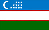
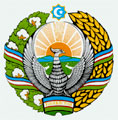
Uzbekistan at a glanceFormal name: The Republic of UzbekistanGeographic coordinates: 41 00 N, 64 00 E Area: total 447.400 km2: land: 425.400 km2, water: 22,000 km2 Land boundaries: total: 6.221 km, border countries: Afghanistan 137 km, Kazakhstan 2.203 km, Kyrgyzstan 1.099 km, Tajikistan 1.161 km, Turkmenistan 1.621 km Population: 29 million (January, 2011) Density of population: 50.1 per km2 Capital:Tashkent Language Official language - Uzbek, widely used: Russian, Tajik, Kara kalpak, also English, which is getting popular among youth generation. National currency: Sum. 1 sum=100 tiyin. Structure: Autonomous Republic of Karakalpakistan, 12 provinces, 226 cities and districts. Religion: Islam - 88%, Christian - 9% (more about Religions in Uzbekistan >>>) Time: GMT + 05:00 Electric power: 220 V AC, 50 amp; Standard two-pin plug socket Domain zone:.uz International dialing code: +998 Flag of Uzbekistan The national flag was approved by the Extraordinary 8th Session of the Supreme Council of the Republic of Uzbekistan on November 18, 1991. The national flag was approved by the Extraordinary 8th Session of the Supreme Council of the Republic of Uzbekistan on November 18, 1991.The flag of the Republic of Uzbekistan consists of blue, white and green stripes, separated by two narrow red stripes. A crescent and three rows of twelve stars are situated on the left side of the upper blue stripe. The blue color symbolizes the sky and water as the principle sources of life. The National flag of Amir Timur was also blue in color. The white stripe is the traditional symbol of peace and of moral and spiritual purity. The green stripe symbolizes nature, the new epoch and abundance in the countries where the majority of the population is Islamic. Besides that, this is in harmony with the modern movement of Greenpeace, which protects nature. The red separating stripes symbolize the current of vital energy in any living body and also connect our pure and noble thoughts with the sky and the earth. The crescent of the new moon, along with its traditional historical symbolism, is at the same time a symbol of the birth of republic's independence. The symbolism of twelve stars is connected historically with the solar calendar year, which begins from Navruz and embodies the twelve principles laying in the foundation of state management. Emblem of Uzbekistan The state emblem of the Republic of Uzbekistan was approved by the 10th Session of the Supreme Council of the Republic of Uzbekistan on July 2, 1992. The state emblem of the Republic of Uzbekistan actually absorbed the centuries-old experiences of the Uzbek people. It reflects a blossoming valley and a shining sun. The right side of the valley is set off with wheat and to the left with a cotton plant garland. The octagonal star, symbolizing the unity of the Republic, crowns the state emblem. The holy Muslim symbols of the crescent and the star are placed inside the star. In the center of the emblem there is the holy bird, Khumo, with its spread wings symbolizing magnanimity, nobility and service. These symbols reflect the long way of the Uzbek people towards peace, stability, happiness, wealth and prosperity. A little frame with the inscription "Uzbekistan" is placed in the lower part of the state emblem. The state emblem of the Republic of Uzbekistan was approved by the 10th Session of the Supreme Council of the Republic of Uzbekistan on July 2, 1992. The state emblem of the Republic of Uzbekistan actually absorbed the centuries-old experiences of the Uzbek people. It reflects a blossoming valley and a shining sun. The right side of the valley is set off with wheat and to the left with a cotton plant garland. The octagonal star, symbolizing the unity of the Republic, crowns the state emblem. The holy Muslim symbols of the crescent and the star are placed inside the star. In the center of the emblem there is the holy bird, Khumo, with its spread wings symbolizing magnanimity, nobility and service. These symbols reflect the long way of the Uzbek people towards peace, stability, happiness, wealth and prosperity. A little frame with the inscription "Uzbekistan" is placed in the lower part of the state emblem.
The National AnthemThe state anthem of the Republic of Uzbekistan was approved by the 11th Session of the Supreme Council of the Republic of Uzbekistan at the 12th convocation on December 10, 1992.The lyrics are by Abdulla Aripov and the music by Mutal Bourkhanov.
General Information
Location of Uzbekistan Terrain Elevation extremes Climate Tourist seasons Cuisine Uzbekistan Currency Land use Clothing Luggage Health Insurance Photography in Uzbekistan Drinks Shopping Psychology of bargain Tipping Main industries: Major foreign investors Sports in Uzbekistan Tourism in Uzbekistan Transport in Uzbekistan |
Booking Online
BOOK NOWAddress
- Address: 4 Umarova street, Samarkand, Uzbekistan
Location

Provinces of Uzbekistan The Province of Andijan is situated in the easternmost part of the country. It borders with Namangan province. In the north and in the northwest, with the Republic of Kyrgyzstan - in the east, with Ferghana province - in the south and in the southwest. The climate is typically continental with extreme variations between winter and summer temperatures. The Province of Andijan is situated in the easternmost part of the country. It borders with Namangan province. In the north and in the northwest, with the Republic of Kyrgyzstan - in the east, with Ferghana province - in the south and in the southwest. The climate is typically continental with extreme variations between winter and summer temperatures.Administrative center: Andijan (359,500 inhabitants) Area: 4,3 square kilometers Population: 2,409,800 and the average density is 560 people per square kilometer Automobile codes: 60 The Province is divided into 14 administrative districts: Andijan, Asaka, Balykchi, Bulokboshi, Buz, Jalalkuduk, Izboskan, Markhamat, Oltynkul, Pakhtaobod, Ulugnor, Khuzhaobod, Shakhrikhon, Kurgontepa. Multiple deposits of oil, ozokerite and lime represent the mineral resources of the Province. There are presently 85 joint ventures registered here. Foreign trade turnover totaled US $1.164 billion in 1997. Andijan Regional Khokymiyat Address: 170120, Andijan, 239, Abdurauf Fitrat str. Tel.: (+998-74) 222-25-82, 222-25-13 Fax: (+998-74) 222-19-32 www.andijan.uz The Bukhara province is situated in the western central part of Uzbekistan. It borders with Navoi province in the north and in the east, with Kashkadarya province - in the southeast, with the Republic of Turkmenistan - in the south, and with Khorezm province and Karakalpakstan - in the west. The Kizil-Kum Desert takes up a large portion of its territory. The climate is characteristically continental and arid. Administrative center: Bukhara (population 270,600) Area: 40,32 square kilometers Population: 1,545,100, about 68% of whom live in the rural areas, while the other 32% live in urban centers Automobile codes: 80 The Province is divided into 11 administrative districts: Bukhara, Vobkent, Zhondor, Kogon, Olot, Peshku, Romitan, Shofirkon, Korovulbozor, Korakul, Gizhduvon. Bukhara Regional Khokymiyat Address: 200118, Bukhara, 1, Ibrokhim Muminov Str. Tel.: (+998 65) 224-41 10 Fax: (+998 65) 223-05 95 www.bukhara.gov.uz, www.bv.uz
|
 The Province of Navoi is situated in the southwestern part of Uzbekistan, bordered by Kazakhstan and Turkmenistan, in the middle of the Kizil-Kum Desert. The climate is typically continental and arid. The Province of Navoi is situated in the southwestern part of Uzbekistan, bordered by Kazakhstan and Turkmenistan, in the middle of the Kizil-Kum Desert. The climate is typically continental and arid.Administrative center: Navoi (population 122,900) Area: 110,990 square kilometers Population: 819,500, with about 59.4% living in rural areas and 40.6% living in towns Automobile codes: 21 - valid till 01.01.2011; 85 - valid for new automobile numbers The province is divided into 8 administrative districts. Other towns are Kisiltepa, Nurata, Uchkuduk, Zarafshan, and Yangirobad.
|


